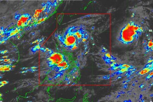
QUEZON CITY -- The Office of Civil Defense (OCD) continues to coordinate response operations with its regional counterparts and other government agencies to ensure assistance in the Typhoon “Goring” affected areas.
“Together with other government agencies and uniformed services, we continue to ensure that everything needed for response operations is in place. On the part of OCD, as the executive arm of the NDRRMC, we continue to monitor the situation and coordinate response operations. We have activated the emergency preparedness and response or the EPR protocols in various regions. These are prescribed measures that need to be taken in the areas. Also, the National Disaster Risk Reduction and Management Council (NDRRMC)’s response clusters, led by different agencies, were activated.” said Undersecretary Ariel Nepomuceno, Civil Defense Administrator and NDRRMC Executive Director.
As of 5:00AM today, Typhoon “Goring” was spotted 210 kilometers East of Casiguran, Aurora with maximum sustained winds of 175 km/hour and gustiness of 215 km/h. It is forecast to intensify into a super typhoon in the coming days and make a close approach to Batanes on Wednesday.
"Posible ho by tomorrow ay maging super typhoon category uli itong bagyong 'Goring,' kasi ho kapag nasa karagatan nandoon pa rin ang posibilidad nito na lumakas. At hindi natin inaalis ang posibilidad na 'yung bagyong 'Goring' ay mag-landfall po. Pinakamalapit sa kalupaan ng ating bansa, partikular na d'yan ho sa Batanes, bandang araw ng Miyerkules," the Philippine Atmospheric, Geophysical and Astronomical Services Administration (PAGASA) said in its weather update broadcast.
"Kaya sa mga kababayan natin sa Batanes, sa ngayon ho kasi nasa signal number one ang nakataas na babala sa lugar na 'yan. Inaasahan ho natin posibleng lumapit at mag-landfall ang bagyong 'Goring,' dito sa Batanes. Mag-landfall man o hindi, inaasahan pa rin natin magiging malaki ho 'yung epekto ng bagyong 'Goring' sa mga kababayan natin partikular na sa bahagi ho ng Batanes." the state weather bureau added.
Meanwhile, a tropical depression outside the Philippine Area of Responsibility (PAR) is also being monitored by PAGASA which may enter by Thursday and will be named “Hanna.” TY “Goring” may exit PAR on Thursday afternoon or evening.
The enhanced southwest monsoon due to “Goring” is also affecting the areas of Luzon and Visayas.
As of today, a total of 2,302 families were already affected by "Goring" while no casualties have been reported.
“As of Monday, no reported casualties po tayo. We hope for zero casualty that’s why we reiterate our call on everyone to remain vigilant and follow authorities’ warnings and advisories. Of course, on our part, we continue to implement necessary measures from national down to local to ensure the safety of the communities. We’re currently dealing with ‘Goring’ and the enhanced southwest monsoon. Now, another weather disturbance will possibly enter PAR this week thus we need the continued cooperation of everyone.” said Usec. Nepomuceno.
"The coordination among response clusters is continuous. We have standby funds and prepositioned relief stockpile amounting to PHP2.4 billion from DSWD and OCD. Our emergency telecommunications, medical logistics, SRR assets, and other resources are also ready." the undersecretary added.
For a systematic response, the Philippine government has 11 response clusters. These are (1) Search, Rescue, and Retrieval; (2) Health; (3) Internally Displaced Population; (4) Camp Coordination and Camp Management; (5) Food and Non-Food Items; (6) Logistics; (7) Law and Order; (8) Emergency Telecommunications; (9) Education; (10) Philippine International Humanitarian Assistance; and (11) Management of the Dead and Missing.
To view the situation report relative to "Goring," the public may access this link: https://monitoring-dashboard.ndrrmc.gov.ph/page/reports/situational-report-for-tropical-cyclone-goring-2023. (OCD)


