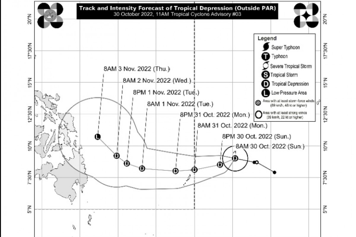
QUEZON CITY (PIA) --The country's weather bureau has alerted the public of another tropical depression(TD) that may enter PAR tomorrow morning which will be named "Quennie."
PAGASA said the weather disturbance outside the PAR maintains its strength of maximum sustained winds of 45 kph near the center with gustiness of up to 55 kph.
This weather disturbance is forecast to remain as a TD until Tuesday and may weaken into a remnant low on Wednesday or Thursday. This weather system is unlikely to directly affect the country throughout the forecast period, PAGASA said.
The weather bureau advised the public and DRRMOs to continue monitoring for updates related to the tropical cyclone.
Tropical Storm Paeng, meanwhile, is moving over the West Philippine Sea exiting the Philippine Area of Responsibility tomorrow morning or afternoon
In its 5pm weather bulletin, PAGASA said Tropical Cyclone Signal # 1 is over Cagayan including Babuyan Islands, Isabela, Quirino, Nueva Vizcaya, Apayao, Abra, Kalinga, Mountain Province, Ifugao, Benguet, Ilocos Norte, Ilocos Sur, La Union, Pangasinan, Aurora, Bulacan, Nueva Ecija, Tarlac, Pampanga, Bataan, Zambales, Metro Manila, the western and central portions of Batangas (San Nicolas, Calaca, Cuenca, Lian, Tuy, Balayan, Talisay, Agoncillo, San Pascual, Santo Tomas, Bauan, San Jose, Calatagan, San Luis, Lemery, Lipa City, Ibaan, City of Tanauan, Mabini, Mataasnakahoy, Alitagtag, Balete, Tingloy, Nasugbu, Batangas City, Laurel, Santa Teresita, Taal, Malvar), Cavite, Laguna, Rizal, the northwestern portion of Oriental Mindoro (San Teodoro, Puerto Galera, Baco), the northwestern portion of Occidental Mindoro (Abra de Ilog, Mamburao, Paluan, Santa Cruz) including Lubang Islands, and the northern portion of Quezon (General Nakar, Infanta).
Areas under Wind Signal No.1 may continue to experience strong winds (strong breeze to near gale strength).
Moderate to heavy rains are possible through tomorrow morning over Zambales, Bataan, Aurora, Pangasinan, Batanes, and the northern portion of Cagayan including Babuyan Islands. Light to moderate with at times heavy rains possible over Metro Manila, Cordillera Administrative Region, CALABARZON, MIMAROPA, Western Visayas, and the rest of Cagayan Valley and Central Luzon. (CPC/PMD)