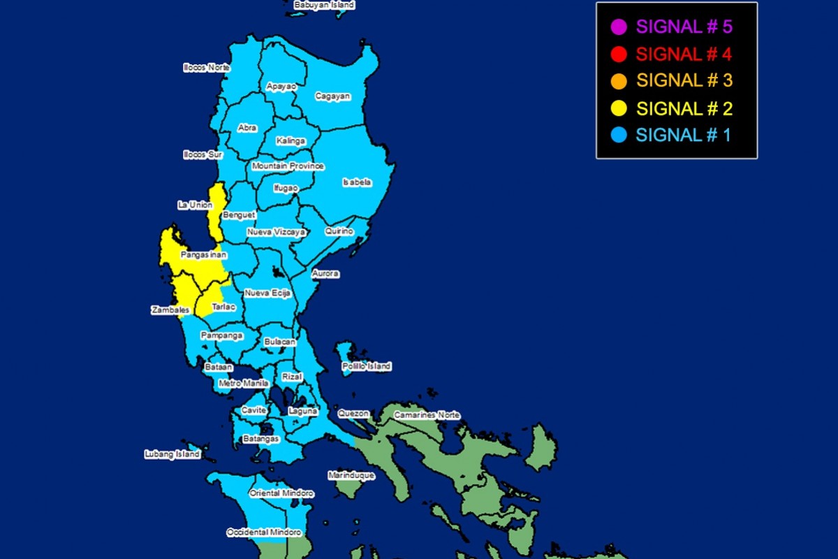
RIZAL (PIA) -- Tropical Cyclone Wind Signal (TCWS) No. 2 was hoisted over four (4) areas on Sunday as Tropical Storm Paeng (international name: Nalgae) continued to move west northwestward over the West Philippine Sea, PAGASA said in its 11:00 a.m. bulletin.
TCWS No. 2 is hoisted over the following areas:
- La Union
- Central and western portions of Pangasinan (San Fabian, San Jacinto, Mapandan, Santa Barbara, Malasiqui, Bautista, Alcala, Urbiztondo, Mangatarem, Basista, San Carlos City, Calasiao, Mangaldan, Dagupan City, Binmaley, Aguilar, Bugallon, Lingayen, Labrador, Infanta, Dasol, Mabini, Sual, City of Alaminos, Burgos, Agno, Bani, Bolinao, Anda, Bayambang)
- Northwestern portion of Tarlac (Camiling, San Clemente, Santa Ignacia, Mayantoc, San Jose, Moncada)
- Northern portion of Zambales (Santa Cruz, Candelaria, Masinloc, Palauig, Iba)
These areas may experience gale-force wind greater than 62 kph and up to 88 kph in at least 24 hours which may pose minor to moderate threat to life and property.
TCWS No. 1 meanwhile was raised over the following areas:
- Cagayan including Babuyan Islands
- Isabela
- Nueva Vizcaya
- Quirino
- Apayao
- Ifugao
- Mountain Province
- Kalinga
- Abra
- Benguet
- Aurora
- Bulacan
- Nueva Ecija
- Pampanga
- The rest of Tarlac
- The rest of Zambales
- Bataan
- Ilocos Norte
- Ilocos Sur
- The rest of Pangasinan
- Metro Manila
- Batangas
- Cavite
- Laguna
- Rizal
- Northern and central portions of Quezon (Lucena City, Pagbilao, Infanta, Tiaong, Unisan, Plaridel, San Antonio, Alabat, Candelaria, Lucban, Sampaloc, Padre Burgos, Sariaya, City of Tayabas, Mauban, Dolores, General Nakar, Perez, Agdangan, Atimonan, Real) including Pollilo Islands
- Northern and central portions of Occidental Mindoro (Abra de Ilog, Mamburao, Santa Cruz, Paluan, Sablayan) including Lubang Island
- Northern and central portions of Oriental Mindoro (Naujan, Puerto Galera, Victoria, San Teodoro, Baco, City of Calapan, Pola, Socorro, Pinamalayan, Gloria, Bansud)
Under TCWS No. 1, said areas may expect strong winds of 39-61 kph in at least 36 hours
At 10:00 a.m., the center of 'Paeng' was estimated to be at 225 km west northwest of Iba, Zambales or 240 km west of Dagupan City, Pangasinan carrying maximum sustained winds of 85 kilometers per hour (kph) near the center and gustiness of up to 105 kph.
'Paeng' is moving west northwestward at 25 kph. From its center, strong to gale-force winds are extending outwards up to 650 km.
'Paeng' is expected to exit the Philippine Area of Responsibility (PAR) on Monday morning or afternoon. (EEDC/ PIA-CPSD)


