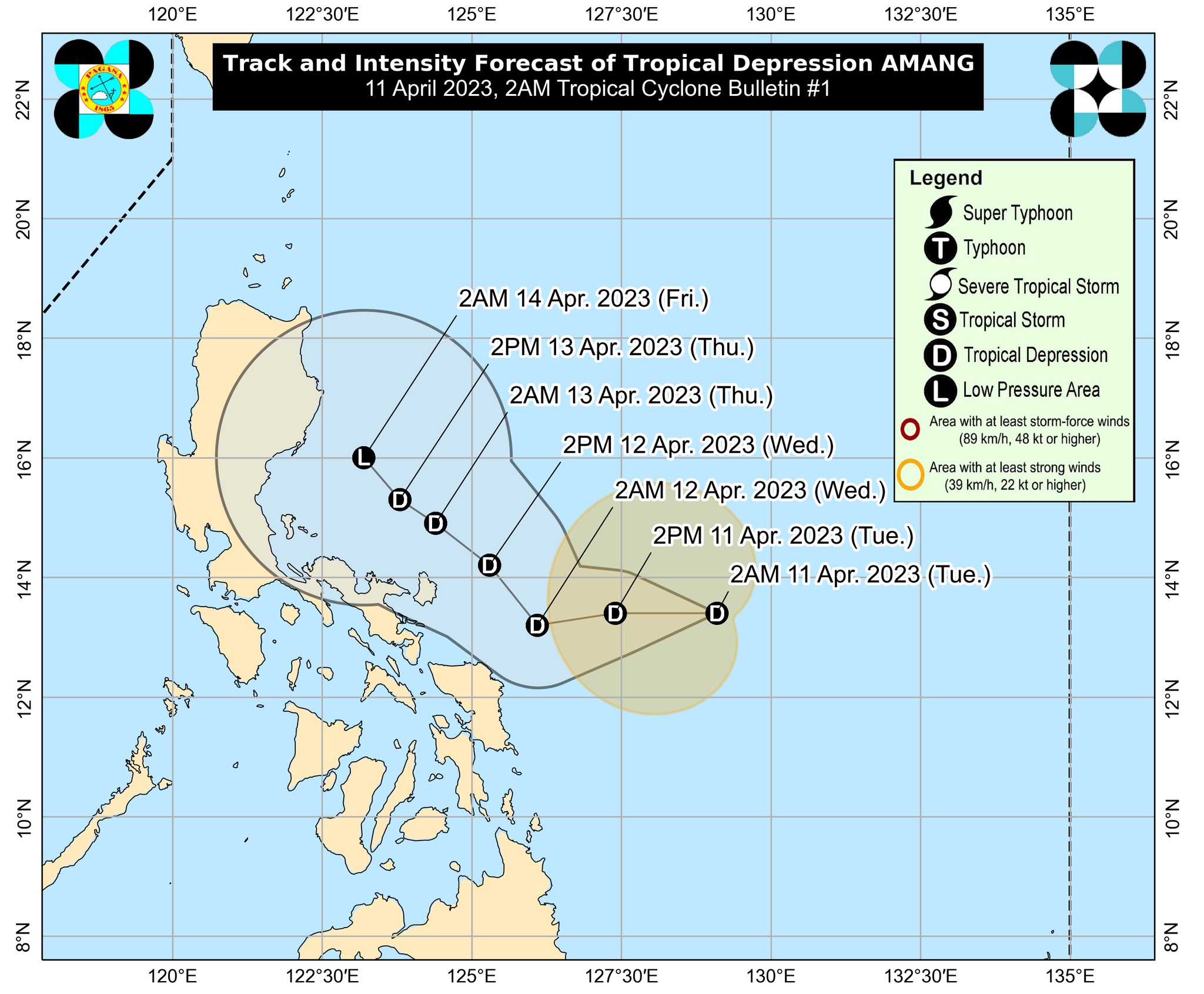
QUEZON CITY (PIA) -- The Philippine Atmospheric, Geophysical and Astronomical Services Administration (PAGASA) reported on Tuesday, April 11, that the Low Pressure Area being monitored was developed into a Tropical Depression and was named ‘Amang’.
At 4:00 AM today, the center of Tropical Depression "Amang" was estimated based on all available data at 475 km East of Virac, Catanduanes (13.3°N, 128.6°E), with maximum sustained winds of 45 kph near the center and gustiness of up to 55 kph. It is moving West Northwest at 20 kph.
Northern Samar and Eastern Samar may experience rains with gusty winds. Moderate to heavy with at times intense rains may possibly cause flooding or landslides. There will be minimal to minor threats to lives and properties due to strong winds.
Meanwhile, Central Visayas, CARAGA, Bicol Region, and the rest of Eastern Visayas will experience cloudy skies with scattered rain showers and thunderstorms. Possible flash floods or landslides due to moderate with at times heavy rains.
Tropical Cyclone Wind Signal No. 1 is already raised over Catanduanes, the northern portion of Eastern Samar (Taft, Can-Avid, Sulat, Dolores, Oras, Arteche, San Policarpo, Jipapad, Maslog, San Julian) and the eastern portion of Northern Samar (Catubig, Lapinig, Gamay, Mapanas, Palapag, Laoang, San Roque, Pambujan, Mondragon).
Persons living in these areas are advised to do the following inspect their houses if necessary repair/fixing is needed; Clean up the drainage system; Harvest crops that can be yielded; and Monitor the latest Severe Weather Bulletin issued By PAGASA every six hours and hourly updates.
For the next 24 hours, ‘Amang’ is forecast to track generally westward towards Bicol Region before turning northwestward for the remainder of the forecast period. While the current track forecast shows that the tropical depression will remain offshore over the waters east of Luzon for the next 3 days, the forecast confidence cone shows that a landfall scenario over the Bicol Peninsula area or the northern portion of Samar Island is not ruled out, especially for the next 36 hours.
‘Amang’ is forecast to remain as a tropical depression, with the possibility of weakening into a low pressure area by late Thursday or early Friday.
The public and disaster risk reduction and management offices in the concerned areas are advised to take all necessary measures to protect life and property. Persons living in areas identified to be highly or very highly susceptible to hazards are advised to follow evacuation and other instructions from local officials.
Further, Gale Warning Advisory was issued to the eastern seaboard of Southern Luzon and the northern and eastern seaboards of Visayas (the eastern coast of Catanduanes, the northern and eastern coasts of Northern Samar, and the eastern coast of Eastern Samar). This is due to strong winds and rough sea conditions associated with Tropical Depression ‘Amang’. Fishing boats and other small seacrafts are advised not to venture out into the sea while larger sea vessels are alerted against big waves.
TD ‘Amang’ is the first tropical cyclone to develop in the Philippine Area of Responsibility for the year 2023. (KSAA – PIA CPSD with information from PAGASA)