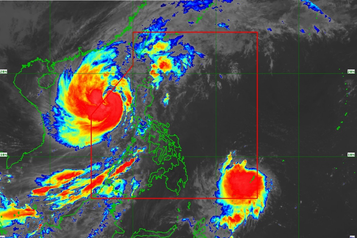
RIZAL (PIA) -- Tropical Storm 'Paeng' has reintensify into a severe tropical storm while moving over the West Philippine Sea, Philippine Atmospheric, Geophysical and Astronomical Services Administration (PAGASA) said on late Monday morning.
In its 11:00 a.m. weather bulletin, PAGASA raised Tropical Cyclone Wind Signal (TCWS) No. 1 over the following areas:
- Southern portion of Ilocos Norte (Badoc, Pinili, Banna, Nueva Era, City of Batac, Paoay, Marcos, Currimao, Dingras, Solsona, Sarrat, San Nicolas, Laoag City, Piddig)
- Ilocos Sur
- La Union
- Pangasinan
- Western and central portions of Pampanga (Mexico, Porac, Angeles City, Santa Rita, Santa Ana, Guagua, Sasmuan, Mabalacat City, Arayat, Santo Tomas, Minalin, City of San Fernando, Bacolor, Floridablanca, Magalang, Lubao)
- Abra
- Benguet
- Western portion of Mountain Province (Besao, Tadian, Bauko, Sabangan, Sagada)
- Western portion of Ifugao (Tinoc, Hungduan)
- Tarlac
- Western portion of Nueva Vizcaya (Santa Fe, Kayapa)
- Western portion of Nueva Ecija (Cuyapo, Talugtug, Nampicuan, Guimba, Licab, Quezon, Zaragoza, San Antonio, Cabiao)
- Zambales
- Central and southern portions of Bataan (Orani, Abucay, Hermosa, Samal, Morong, Dinalupihan, Bagac, City of Balanga, Pilar)
At 10:00 a.m., 'Paeng' was located 375 km west of Dagupan City, Pangasinan, with maximum sustained winds of 95 kph near the center and gustiness of up to 115 kph.
At present, it is moving northwestward at 10 kph. It has strong to gale-force winds that extend outwards up to 650 km from the center.
'Paeng' is expected to exit the Philippine Area of Responsibility (PAR) this afternoon or evening, PAGASA said.
Meanwhile, Tropical Depression 'Queenie' has already entered the PAR. (EEDC / PIA-CPSD)


